Friday, February 1, 2008

Freezing Rain and Icicles


Area schools closed today in anticipation of accumulating ice as significant freezing rain fell during the day.

The rain started falling around 10 AM, with my digital thermometer reading 32.5 degrees F. It's been raining liquid water and an occasional ice pellet ever since then (it's now after 2 PM) and whatever is falling is freezing on contact. The picture here is of icicles that formed as liquid water ran off the car and froze.

What's interesting is that the temperature on my digital thermometer has remained constant - right at the freezing point - all day, even though other local stations are reporting slightly colder temps. I think the reason for the constant temp on my thermometer is due to the fact that the sensor in my yard is getting wet, and the water on it is freezing and holding the temperature right at the freezing point.

I've posted a few more icicle pics here.

Venus and Jupiter in the Morning Sky

If any of you have a good view to the southeast just before sunrise, you've probably noticed Venus and Jupiter coming closer and closer to each other over the last couple of days.
This morning, they are in conjunction, passing within just .6 degrees from each other (that's just a hair more than the Moon's diameter). They are located just above the handle of the "teapot" in Sagitarius (the constellation that dominates the southern sky during summer evenings). It's cloudy here this morning, so I won't be able to get a picture, but I did steal this image from Stellarium (stellarium.org).
You can get a full size image here: http://www.stevekluge.com/geoscience/images/venusjupiter2_2008.jpg

During the coming weekend, the old crescent moon will move across this part of the sky from the upper left to the lower right. Hopefully I'll get some pics.

Wednesday, January 23, 2008

Some Interesting Weather Observations

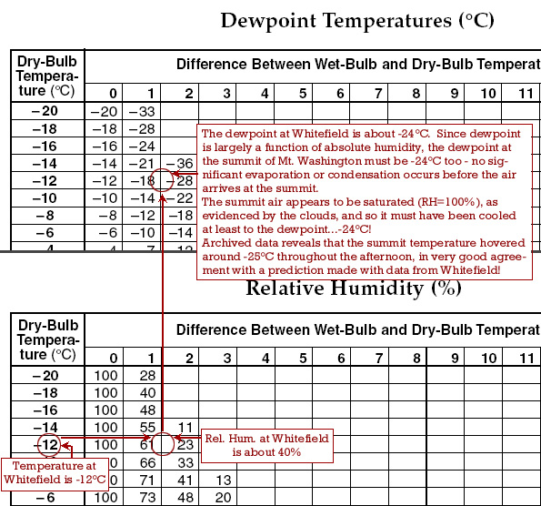
The cold, cP air that covered the region last weekend presented some pretty interesting opportunities to explore some of the atmospheric phenomena we study in earth science classes. When a colleague in New Hampshire sent the image of Mt. Washington ("Home of the World's Worst Weather), I began looking at data from the area where the photo was taken, and from the summit of Mt. Washington. What I soon realized was that in this fairly uniform and stable air mass, I could predict the temperature at the summit based on observations at the location where the photo was taken. That night, temperatures on the summit dropped to -31°C - cold to be sure, but not as cold as it might have been.
The two exercises below will help you understand what was going on.
Mt Washington, NH Weather Part 1 and Part 2 (solution to Part 1)
See the solution to Part 1 only if you are stuck (or want to check your answers). You can email if you want an explanation of Part 2.

Tomorrow, I'll post another quick exercise involving the heating and cooling of descending and rising air.

Monday, January 14, 2008

False Alarm on the Big Snow?


Kind of a false alarm on the snow, eh? Look at this weather map from Sunday night into Monday morning (Click the map if you can't see the animation). Subtract 5 hours from the time displayed at the lower left for NY time, and notice that the storm center stayed well out to sea, "wasting" a lot of good snow on the ocean!
A small change in the track of the storm can make a huge difference in the weather a particular area experiences.
Oh well, you got your 2 hour delay in SE NY this morning, right?

Sunday, January 13, 2008

Nor'easter for us this week!

It's been a while since I've posted anything here - so here's wishing you all a belated Happy and Healthy New Year. I've enjoyed seeing some of you during my brief visits to Fox Lane, and hope to see more of you when I'm there again.

A strong low pressure system is developing off the coast of the SE US as I write this, and by this evening it will have moved northward toward the NY area. It is predicted to remain off-shore, so we will be in the easterly and then northeasterly* flow of moist air circling counterclockwise and in off the Altlantic around the low.

Check out the current and forecast weather maps at Accuweather.

That relatively warmer and moist maritime air will override the cooler air already in place over us (remember, warmer and moist air is less dense than cooler, dry air), and as it rises, expands, and cools the moisture in it will condense and fall as snow through the cooler air below. As of noon today (Sunday), the national weather service is predicting 8 to 12 inches of snow in our area.

As the low moves northeastward out to sea tomorrow afternoon, we'll experience a shift in the wind to the northwest, ushering in a little cP from Canada, and another low that's currently spinning around the Great Lakes.
Read more about the developing storm at the Accuweather web site, and check for school closings or delays at your school web page or, in SE New York here
*That's why it's called a nor'easter!

Saturday, December 8, 2007

The Earliest Sunset!

Well, we've made it. Tonight was the earliest sunset of the year!
Every decent earth science student knows that today was NOT the shortest day (that's on the Winter Solstice around December 21), but not a lot of people can explain tonight's early sunset. It turns out that the rate at which the Sun travels across the sky is not constant - the tilt of Earth's axis and its elliptical orbit conspire to push the Sun ahead of our clocks, and then slow it down again, twice every year. Astronomers call the difference between time told by the Sun (apparent solar time) and clock time (mean solar time) the "equation of time".
The chart on the left above, called the analemma, combines the equation of time with the position of the Sun relative to the equator. Click it for a larger view, and notice that through most of the fall the Sun has been running ahead of the clock, but in December it began to slow dramatically.
It's the Sun slowing down relative to the clock that's moving the daylight period later into the day even as the days get shorter!
This photo composite was made by Tom Matheson over the course of a year, snapping a picture of the Sun at exactly 8 AM (by the clock) each day. Here is a labeled image of Tom's photo.

Saturday, November 24, 2007

Clear Skies....Get Yer Coat On and Get Out There!


We're in for a few days of clear skies, and even though the nearly full Moon will dominate the entire night sky for the next few days, you should bundle up and get out for a little bit of winter sky orientation. The Moon's light will make observation of Comet Holmes difficult if not impossible.
Moonlight will wash out all but the brightest stars, but you can use that fact to help you locate the bright stars of the "Winter Hexagon".
Refer to this PowerPoint file (The Winter Hexagon) to learn to know the 6 bright stars that mark the winter skies. (if you need a PowerPoint viewer, get it here) Tonight the Moon is between Aldebaran and Capella, and over the next few evenings it will work its way toward a close encounter with Mars - between Capella and Pollux - on the night of 11/26.
For good viewing you should have a clear view of the sky to the EastSouthEast of you, and be as far from artificial lighting as you can get. Give your eyes about 15 minutes to adjust to the dark once you're outside (that's why you want yer coat on!)
And I've turned on the comments option, so let everyone else know if you get out there, and what you're able to see.